Wednesday, December 6, 2023

Marine weather forecasts - custom shading - major update

 We are pleased to announce a major update to our marine weather forecast visualization in the i-Boating app. The latest version support color shading marine weather forecasts into multiple zones based on safe /comfortable values customizable under settings.

For e.g. based on comfortable wave height setting, the map is color coded into multiple zones:

  • Safe zone: Transparent -> Green
  • Caution zone: Yellow
  • Danger Zone: Red
I have included below a screenshot where safe wave height is set to 3ft. Note how the red zone is much bigger. When I change it to 4.5 ft, the red zone shrinks.


As always the update is immediately available on Windows, MacOS, iOS, Android and Linux/Raspberry Pi (selective partners).

Sunday, October 8, 2023

OpenLayers & Nautical Charts Web SDK.

 OpenLayers is an advanced javascript framework for manipulating geospatial data in the web browser. With our latest enhancements to the web SDK, the OpenLayers framework is now fully compatible with the Marine Charts Web SDK.

With the latest version, its as simple as the following. 

<!--  Create nautical_layer layer. It can be passed in the map constructor or added via addLayer  -->
var nautical_layer = blc_ol_nautical_layer.BlcOlNauticalLayer({ container:'map',.....
}
);

No other changes to your OpenLayers project are required.

If you wish to add marine charts and lake maps to your web-application, contact us for a trial key and pricing.


Sunday, October 1, 2023

i-Boating Marine & Lake Maps Web SDK update

 The i-Boating Marine & Lake Maps Web SDK has had a major update. It now supports popular web mapping libraries out of  the box. With just a  few lines of code, now you can add nautical charts & lake maps to your web project.

The following popular web mapping frameworks are supported:

  • Leaflet
  • Openlayers
  • Google Maps
  • Bing Maps V8
  • Azure Maps
  • Mapbox GL JS
If you wish to add marine charts and lake maps to your web-application, contact us for a trial key and pricing.

Monday, September 25, 2023

Mapbox GL JS & Nautical Charts

 Mapbox GL JS is a javascript library for interactive vector maps on the web.  The  i-Boating Marine Charts Web SDK is now fully compatible with this mapping library.

With a few lines of javascript code, you can now add nautical charts overlay to your mapbox gl js web application.

Its as easy as this.

<!-- This will add nautical charts overlay to your mapbox gl js app -->

            new blc_mapbox_nautical.BlcMapboxAdatper(map, { container: 'nautical_map', blc_access_token:'BLC_ACCESS_TOKEN' });

If you wish to add marine charts and lake maps to your web-application, contact us for a trial key and pricing.


Sunday, September 24, 2023

Nautical Charts & Azure Maps

 Azure Maps for the web is an advanced GeoSpatial API to build intelligence location aware apps. The i-Boating Marine Charts Web SDK is now fully compatible with Azure maps.

 With just a few lines of javascript SDK, now you can add Nautical Charts to your Azure maps web application.

Its as easy as this.


<!--  This will add Nautical Charts overlay over Azure Maps -->

          new blc_azure_nautical.BlcAzureAdatper(map, { container: 'nautical_map', blc_access_token:'BLC_ACCESS_TOKEN' });


If you wish to add marine charts and lake maps to your web-application, contact us for a trial key and pricing.

Saturday, September 23, 2023

Bing Maps & Nautical Charts

 Bing Maps API, an excellent feature rich mapping platform by Microsoft is fully compatible with i-Boating Marine Charts SDK

Adding nautical charts overlay to Bing Maps is as simple as adding a few lines of javascript code.

<!-- This will add nautical charts overlay on Bing Base Map -->

            var overlay = new BlcNauticalOverlay(map, { blc_access_token:'YOUR_ACCESS_TOKEN' } );

           //Add the custom overlay to the map.

            map.layers.insert(overlay);

If you wish to add marine charts and lake maps to your web-application, contact us for a trial key and pricing.


Friday, September 22, 2023

Google Maps with Nautical Charts

 The i-Boating Web SDK is compatible with Google Maps Javascript API. If you have a web project built on Google Maps platform and if you wish to add marine charts and lake maps layer to your project with minimal changes, the i-Boating Marine Charts SDK is the ideal solution for you.

Its as easy as:

<!-- This will add Nautical Charts overlay over Google Maps  -->

const overlay = new BlcNauticalOverlayGoogle(map, {blc_access_token:'BLC_ACCESS_TOKEN'});

  overlay.setMap(map);

If you wish to add marine charts and lake maps to your web-application, contact us for a trial key and pricing.


Thursday, September 21, 2023

Using Leaflet to render Nautical Charts and Lake Maps.

 Leaflet, the open source javascript library for web-mapping applications is fully compatible with the i-Boating Web SDK. If you have a web-mapping project built using Leaflet, now you can easily add a nautical chart layer to your project.

You can add nautical charts to your leaflet map with a  few lines of code.

Its as easy as this.

<!--  This will add nautical charts to the map -->

var gl = L.blcGL({

    blc_access_token:'BLC_ACCESS_TOKEN'

}).addTo(map);

If you wish to add marine charts and lake maps to your web-application, contact us for a trial key and pricing.

Tuesday, August 29, 2023

Lake Breakdowns for Fishing

 The i-Boating app includes lake breakdowns for fishing for mapped inland lakes worldwide. This is made possible by the Fishing AI™. I recently discussed in a youtube post how Fishing AI works.

Its like having a fishing professor do the lake breakdown to identify areas that are great for fishing.

  • Available for all inland lakes worldwide
  • Get  GPS coordinates for fishing breaklines and spots to use in your fish finder
  • Narrow down the part of the structure where you should focus
  • Aid for tournament preparation & fishing strategies from the comfort of your couch


Saturday, August 5, 2023

i-Boating tops the most respected, unbiased, consumer reports like survey of Marine Navigation Apps by Captain Farmer

 i-Boating recently topped the most respected, unbiased, consumer reports like  survey of marine navigation apps. The survey was done by Captain John Farmer (Retired).  I call this a consumer reports like survey because Captain Farmer purchased all the apps included in the survey at retail, just like consumers. I have embedded below the youtube video of the review


Thursday, June 22, 2023

Fishing Hotspots AI

 We are pleased to announce a major update to the i-Boating application. All our customers now have access to the Fishing AI, a large scale AI model that emulates an expert angler to identify fishing breaklines and fishing hotspots.

Some of the variables that it takes into account are:

  • Lake bathymetry/topography
    • Point Bars
    • Humps / Underwater Islands
    • Channels
    • Saddles
    • Artificial / Man Made Structures
    • River Bed
    • Ledges
    • Side Feeder Streams
    • Pits
    • And more...
  • Local Knowledge for a lake gained over the years
  • Weather Patterns
  • Vegetation Maps

I have included a tutorial video showing this in action.


It is available on all platforms - Android, iOS, Windows and MacOS. 

Wednesday, June 7, 2023

Crowley lake depth map for fishing

 Crowley lake, famous for Trout fishing is fully supported in the i-Boating app. Its one of the best trout fishing lakes in California.

Crowley Lake Fishing Map

Crowley Lake Fishing Map


Tuesday, June 6, 2023

Claytor Lake, Virginia, ENC Chart

 We are pleased to announce the availability of Claytor lake, Virginia ENC chart.  We have tried to included most requested layers in the electronic lake depth map for Claytor, including but not limited to:


  • HD depth contours / bathymetry
  • Obstruction/Hazards/Shoal Areas
  • Rocks
  • Fish  Structures 
  • Boat ramps
  • Fishing Piers

We have been tracking this lake in our internal tracking system even before the i-Boating app was published.  I added this in our tracking system in 2014. We were finally able to acquire enough data for this lake to release mapping for it today. I am very happy to finally be able to close that tracking bug. Its been a long time coming. 

Claytor Lake Depth Map

Claytor Lake Depth Map


Monday, May 15, 2023

Single marine charts folio covering UK, Ireland, France and Netherlands

 We are pleased to announce that we now have a unified folio covering UK, Ireland, France and Netherlands

The folio also includes charts for inland rivers and canal system in UK and Netherlands (including depth maps with HD bathymetry). In addition to coastal charts, we have also incorporated French inland rivers and lake maps.

Its already available for Android and iOS.
It will be available soon for MacOS and Windows.

Wednesday, April 26, 2023

Offline i-Boating WMTS (Web Map Tile Service - Marine Charts & Lake Maps)

 We are pleased to announce the availability of i-Boating WMTS, an application supported on Windows &  MacOS. 

The i-Boating WMTS is  a dynamic web map tile service that runs on your localhost and provides coverage for marine charts and lake depth maps. Its the most customizable marine WMTS and compatible with QGIS, ArcGIS, ArcGIS online, Grassgis and any software compatible with the OGC WMTS standard.

Its the only Marine Charts WMTS that's capable of running offline and more customizable than a chartplotter.

  1. Offline support: Designed for private internal use to run on your localhost even when offline
  2. Change depth unit to feet, meter or fathom
  3. Tile size can be customized to  256, 512 or 1024
  4. Both http and https support
  5. For https, add your own SSL certificate or use our bundled self-signed certificate
  6. Compatible with most GIS software and web - applications including QGIS, ArcGIS, ArcGIS online, GrassGIS and platforms like Here Maps, Google Maps, javascript libraries like Leaflet, Openlayers etc
  7. Choose between Light and dark mode
  8. Custom depth offset
  9. Custom shading 
  10. Option to use an offline basemap
  11. Capable of serving maps till zoom 20

I have included below an introductory video on getting started with the i-Boating WMTS.
We also have an i-Boating WMTS Tutorial video series on youtube. 


Thursday, April 20, 2023

i-Boating Video Tutorials

 We have created a few video tutorial on using the i-Boating app. The tutorial videos are organized in a playlist. 

Here is a list of all topics covered in our video tutorials.

The video have been created on iOS (iPhone/iPad).  
The steps are similar on Android, Windows & MacOS.

Friday, April 14, 2023

NMEA alarms for depth and wind speed are now available in i-Boating

 The latest version of the i-Boating application now lets you set an alarm for depth and wind speed. Its supported on all platforms (iOS, Android, Windows and MacOS).

You must have a working NMEA instrumentation set up in the i-Boating application to use these features. Simply tap/click on the blue text/button showing the depth to set the alarms, adjust thresholds etc.

I've included below a few screenshots with this feature in action.


Thursday, February 23, 2023

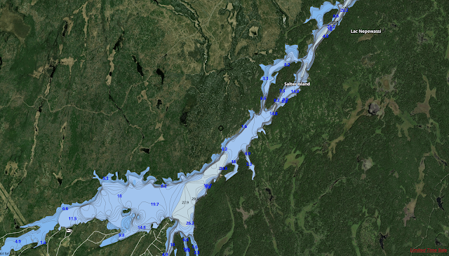
Ontario lakes (Lac Nepewassi) boating and fishing

 i-Boating includes detailed vector charts of inland lakes in Ontario for boating and fishing. Its the largest collection of contour maps for popular Ontario lakes. 

All maps can be downloaded for offline use to your device (Windows, MacOS, iOS, Android). Once downloaded you can study lake topography, identify structure and mark potential fishing spots. GPS features are supported on all platforms and work well on all inland lakes without internet connectivity.


Lake Nepewassi Depth Map

Lake Nepewassi Fishing Map

Lake Nepewassi Boating Map


Thursday, February 16, 2023

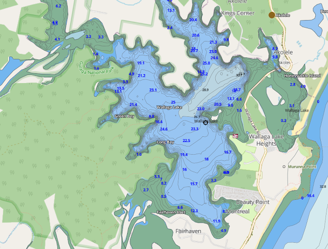
Australia & New Zealand inland lakes

 We have been working to constantly improve our coverage for inland lakes in Australia and New Zealand. We have prioritized lakes and water bodies that have been requested by our customers. If you have the i-Boating app, please update your maps to get access to the new lakes that have been added. If your favorite lake is still missing, please let us know so that we can  follow up on it.


Australia Inland Lakes Fishing Maps

Australia Inland Lakes Fishing Maps

Australia Inland Lakes Fishing Maps